-
Please take a moment and update your account profile. If you have an updated account profile with basic information on why you are on Air Warriors it will help other people respond to your posts. How do you update your profile you ask?
Go here:
Edit Account Details and Profile
You are using an out of date browser. It may not display this or other websites correctly.
You should upgrade or use an alternative browser.
You should upgrade or use an alternative browser.
1,001 questions about the ASTB (post your scores & ask your questions here!)
- Thread starter edato
- Start date
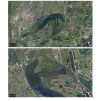
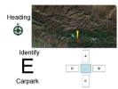
UAV portion is still there, much much easier imo but they are both similar, just imagine the UAV portion just a google map. Don't stress the terrain one, I didn't prepare for it at all and still did decent, I think. Let me get some pictures to sample what a question would look like and that can help explain. What I did was compare the reference picture and UAV sight picture then take my mouse and "draw" a line on the reference picture where the top of the UAV sight picture was then click the compass rose in the bottom to point the same direction. Not sure if I did a good job explaining if not just tell me and I'll figure out a better way.does this replace the UAV portion? And can you explain in depth as well as your tips

I forgot exactly how many questions, I want to say 16-18.Sound a lot like the UAV portion. What are the difference? How many questions. Thanks
Danger95
Well-Known Member
So the same concept applies and if I am correct they give you a practice before the test correct?UAV portion is still there, much much easier imo but they are both similar, just imagine the UAV portion just a google map. Don't stress the terrain one, I didn't prepare for it at all and still did decent, I think. Let me get some pictures to sample what a question would look like and that can help explain. What I did was compare the reference picture and UAV sight picture then take my mouse and "draw" a line on the reference picture where the top of the UAV sight picture was then click the compass rose in the bottom to point the same direction. Not sure if I did a good job explaining if not just tell me and I'll figure out a better way.
View attachment 38883
MotorCookie
Well-Known Member
Maybe this could be a new thing @TwoScoops could add to the app?
Danger95
Well-Known Member
Lol how soon can @TwoScoops add it I take the test on Wednesday morningMaybe this could be a new thing @TwoScoops could add to the app?
Same concept just instead of the UAV telling you what way you're heading you figure that out. Yes they give you practice.So the same concept applies and if I am correct they give you a practice before the test correct?
Danger95
Well-Known Member
Based on?Same concept just instead of the UAV telling you what way you're heading you figure that out.
Average Monke
A primate with internet access
Based on the picture given. For example:Based on?

You can practice it here. The only difference is that the building you need to select is told to you audibly, which I found easier than visually.
Edit: apologies, I didn't see that there is brand new subsection. I'll leave my comment if anyone wants to practice the UAV section.
So for this example, would the answer be "West?"UAV portion is still there, much much easier imo but they are both similar, just imagine the UAV portion just a google map. Don't stress the terrain one, I didn't prepare for it at all and still did decent, I think. Let me get some pictures to sample what a question would look like and that can help explain. What I did was compare the reference picture and UAV sight picture then take my mouse and "draw" a line on the reference picture where the top of the UAV sight picture was then click the compass rose in the bottom to point the same direction. Not sure if I did a good job explaining if not just tell me and I'll figure out a better way.
View attachment 38883
It should be East, the top of the UAV sight picture is the direction in which it is heading.So for this example, would the answer be "West?"
Would be neat to see this implemented on the app. Seems very possible to do, although I am no app designer.Maybe this could be a new thing @TwoScoops could add to the app?
Oh wait, I think I see it. The heading was southward, meaning the view of the bottom would be to the east.It should be East, the top of the UAV sight picture is the direction in which it is heading.
Just got out of my second of my second ASTB atempt:
OAR: 56
AQR: 8
PFAR: 9
FOFAR: 9
LPSS: 68
Went to this from a 5-5-6 on my last attempt (just burned an attempt to get an idea what the test was like). I studied about 100+ hours for this test and used the AirWarrior threads to my advantage. I studied all the resources on this reddit post: . I made flashcards for literally everything on these documents and memorized it to a tee. Took me about two months. I also bought a X-52 and practiced the Janzten Sim on Hard until I could get a combined throttle and stick score of -250. I was hitting 220s by the time I took the test. This will make the actual sim seem like babyfood. I also took a look at the Barron's Book: https://www.amazon.com/Barrons-Military-Flight-Aptitude-Tests/dp/1438005695 This has some really good physics questions and math questions. I also used the cram flashcards: https://www.cram.com/flashcards/astb-aviation-nautical-information-test-anit-comprehensive-4718163 The biggest thing I did study was stuff for the ANIT and practiced the shit out of the sim. I didn't bother studying for the reading section at all because its a waste of time in my opinion.
I'm a senior MIDN at the Merchant Marine Academy and will be submitting my package to the navy early next month. I have a 3.0 GPA and don't play any sports. I'm in a running club and also have about 12 hours on my PPL. Hopefully my new score and the fact that I'm applying from a service academy will get me a spot. GOOD LUCK YALL!!!!
