A reminder to always compute your density altitude before high-elevation departures.
And an excellent reminder it is. In addition, alway check out the gradient of the terrain which you will climb out over after liftoff. Example: Kirtland AFB, NM (KABQ) - Elev. 5,300' - Rwy 26-08 - 13,700'. I've departed Kirtland several times in an A-4C, max gross on a typical [hot] summer day. Always used Rwy 26, which allows a slow climb over the Rio Grande River valley. Looong takeoff roll, but no real problem. Had surface winds dictated Rwy 08 as duty...under similar circumstances, I'd have cancelled the flight. Departing ABQ to the east, terrain rises sharply into the foothills of the Sandia Mountains. Many an aircraft crater in the Sandias over the years (30 Sandia crashes since 1935)!
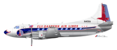
In Feb. 1955, A TWA Martin 404 (Eastern 404 shown above) crashed into the Sandias after departure from ABQ, killing 16.
BzB