• Please take a moment and update your account profile. If you have an updated account profile with basic information on why you are on Air Warriors it will help other people respond to your posts. How do you update your profile you ask?

    Go here:

    Edit Account Details and Profile

Weather

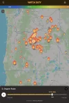
Highly recommend the Watch Duty app. It is free, and tracks all fires across the country.

You can see in Oregon that there’s not a lot of rain and a lot of fire. The two weird fire icons in the middle represent “fire complexes“. That’s where you get a whole slew of separate fires that are treated as one, with the separate fires, resulting from winds blowing embers from spot the spot.
1784474398918.png
 
Living in SE Washington, my Watch Duty app is going off several times per day. Avoided most of the smoke thus far, but a shift in the wind is all it takes. Not great for our vineyards.
 
It appears to me that the next couple of days will be very challenging for the fire crews. You still in your house and OK?
The spot fire that was heading to our town is under control and no longer a threat. The main fire is still going. We are safe and at level 1 (be ready). I moved my truck, travel trailer, and car off my property to my brother’s shop located 2 towns south.


1784514183626.png
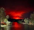
This photo was taken by a friend yesterday evening from the bridge in our town that crosses the Rogue River. It’s a very unsettling and helpless feeling.
 
This report from the Akawa Butte Fire in Oregon…

(Sisters, OR) – Today a pyrocumulus cloud (a dense, puffy cloud created by intense surface heating) formed over the fire prior to the arrival of the forecasted thunderstorms. The pyrocumulus cloud created its own weather system over the fire area and produced its own lightning.

Extreme fire behavior due to critically dry fuels and gusty outflow winds from the afternoon thunderstorms pushed the fire downhill toward Indian Ford and Wilt Roads and has crossed the Stevens Canyon Road. Firefighters encountered 150 to 200-foot flame lengths in requiring all resources to fall back on the south end of the fire and modify tactics to maintain firefighter safety and protect structures.
 
This report from the Akawa Butte Fire in Oregon…

(Sisters, OR) – Today a pyrocumulus cloud (a dense, puffy cloud created by intense surface heating) formed over the fire prior to the arrival of the forecasted thunderstorms. The pyrocumulus cloud created its own weather system over the fire area and produced its own lightning.

Extreme fire behavior due to critically dry fuels and gusty outflow winds from the afternoon thunderstorms pushed the fire downhill toward Indian Ford and Wilt Roads and has crossed the Stevens Canyon Road. Firefighters encountered 150 to 200-foot flame lengths in requiring all resources to fall back on the south end of the fire and modify tactics to maintain firefighter safety and protect structures.
High dew points in the eastern PNW today. Storms starting to pop in extreme NE Oregon right now, and it’s almost 100 at my house. 😬
 
Back
Top