-
Please take a moment and update your account profile. If you have an updated account profile with basic information on why you are on Air Warriors it will help other people respond to your posts. How do you update your profile you ask?
Go here:
Edit Account Details and Profile
You are using an out of date browser. It may not display this or other websites correctly.
You should upgrade or use an alternative browser.
You should upgrade or use an alternative browser.
Blackhawk / CRJ-700 Midair
- Thread starter Meyerkord
- Start date
Where else would the helicopters go?Before we are too critical of pilots, maybe we should see who thought that crossing flight routes where 100-200 feet deviations would be fatal was a good idea .
Between USMC, USA, USAF VIP birds, USCG and CBP enforcing the ADIZ, and multiple federal, state, and local LE agencies, there are a lot of birds and only so many routes not over population—basically the major highways and the river.
I’m willing to bet a dollar that I-295 becomes the new corridor. I can afford a dollar.Where else would the helicopters go?
Between USMC, USA, USAF VIP birds, USCG and CBP enforcing the ADIZ, and multiple federal, state, and local LE agencies, there are a lot of birds and only so many routes not over population—basically the major highways and the river.
And now, you can get to IAD on the Silver Line - super easy as wellConcur. Getting to DCA on the Metro (or Uber) is super easy... both of which are claimable on DTS
Sure, but how long does that take from downtown?And now, you can get to IAD on the Silver Line - super easy as well
.8 to 1.0 from downtown. .3 from my station in AshburnSure, but how long does that take from downtown?
Metro? That’s in days, right?.8 to 1.0 from downtown. .3 from my station in Ashburn
Turns out one of the Blackhawk pilots was a prior enlisted TACAMO AWV. He was well before my time but many of the senior officers and enlisted I spoke to had nothing but great things to say. RIP to one of our own.
His wife has publicly posted and made known that her husband was one of the Blackhawk pilots lost in the crash, hence me posting this.
His wife has publicly posted and made known that her husband was one of the Blackhawk pilots lost in the crash, hence me posting this.
SighI will say that POTUS has been completely irresponsibly and unhelpful in his clueless public speculation, especially in somehow blaming DEI with no evidence.
One account wrote,: “So now that the pilot of the Blackhawk has been identified as Jo Ellis, a transgender woman, can we admit Trump was right about the entire thing, or is it too soon?”
I can understand why the family of the other pilot, a female, does not want her name released.
Just stupid.Sigh
One account wrote,: “So now that the pilot of the Blackhawk has been identified as Jo Ellis, a transgender woman, can we admit Trump was right about the entire thing, or is it too soon?”
I can understand why the family of the other pilot, a female, does not want her name released.
Yeah, the dude was awesome. Did a bunch of trips with him… Really fucking sad.Turns out one of the Blackhawk pilots was a prior enlisted TACAMO AWV. He was well before my time but many of the senior officers and enlisted I spoke to had nothing but great things to say. RIP to one of our own.
His wife has publicly posted and made known that her husband was one of the Blackhawk pilots lost in the crash, hence me posting this.
A news article read on NewsMax stated that the -60 was on NVGs. I've not seen this anywhere since.
One undisputed fact is that they were above the 200' max altitude on Route 4 when north of the Wilson Bridge.
My thoughts are focused at evaluating a) the impact on visual identification of conflict aircraft due to NVG light source volume/saturation, b) combined with incomplete conflict aircraft call out ("CRJ" vs "CRJ at 11 o'clock"), and c)combined with ~200' above max route altitude.
I am looking at this as a prior DOSS who was part of the investigation team for two Class-A mishaps.
No where do I look for blame, rather causal factors.
One thing I often say to myself while gathering facts and developing causal factors is "How could this have happened to me?", never "I wouldn't have done that."


Do we know they were flying this specific route?A news article read on NewsMax stated that the -60 was on NVGs. I've not seen this anywhere since.
One undisputed fact is that they were above the 200' max altitude on Route 4 when north of the Wilson Bridge.
My thoughts are focused at evaluating a) the impact on visual identification of conflict aircraft due to NVG light source volume/saturation, b) combined with incomplete conflict aircraft call out ("CRJ" vs "CRJ at 11 o'clock"), and c)combined with ~200' above max route altitude.
I am looking at this as a prior DOSS who was part of the investigation team for two Class-A mishaps.
No where do I look for blame, rather causal factors.
One thing I often say to myself while gathering facts and developing causal factors is "How could this have happened to me?", never "I wouldn't have done that."
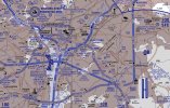
View attachment 41799
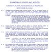
View attachment 41800
Yes, it is the only helo route through there.Do we know they were flying this specific route?
